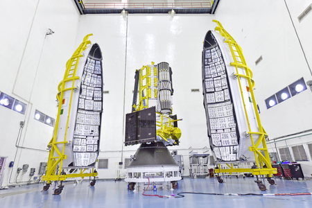
New Delhi, July 26 (IANS) The NASA-ISRO Synthetic Aperture Radar (NISAR), slated for launch next week, is a result of global teamwork and technology, said the Indian space agency.
NISAR is the first joint satellite mission of the Indian Space Research Organisation (ISRO) and NASA.
NISAR will be launched by ISRO’s GSLV-F16 from Satish Dhawan Space Centre (SDSC SHAR) in Andhra Pradesh’s Sriharikota at 5.40 pm. It will be the Geosynchronous Satellite Launch Vehicle’s (GSLV) first launch into a Sun-Synchronous Orbit (SSO).
The NISAR launch is the result of strong technical cooperation between ISRO and NASA/JPL technical teams for more than a decade.
“Built across continents in phases, NISAR is a result of global teamwork and tech. NISAR came together through years of integration and testing,” said ISRO, in a post on social media platform X.
ISRO noted that NISAR has created a milestone of firsts.
NISAR is the “first dual-band radar satellite, it is the first GSLV to SSO, and the first ISRO-NASA Earth observing mission”.
The GSLV-F16 will inject the NISAR satellite into a 743 km Sun-synchronous orbit with an inclination of 98.4 degrees.
“Two space agencies. One big win for Earth. NISAR is the first time @NASA and @ISRO have built Earth science hardware together. This powerful satellite will track changes on land and ice, from areas at risk for landslides and earthquakes to shifting glaciers and ice sheets,” NASA Earth shared in a post on X.
Weighing 2,392 kg, NISAR is a unique Earth observation satellite and the first satellite to observe the Earth with a dual-frequency Synthetic Aperture Radar (NASA’s L-band and ISRO’s S-band), both using NASA’s 12m unfurlable mesh reflector antenna, integrated to ISRO’s modified I3K satellite bus.
NISAR will observe Earth with a swath of 242 km and high spatial resolution, using SweepSAR technology for the first time.
“The satellite will scan the entire globe and provide all-weather, day and night data at a 12-day interval, enabling a wide range of applications.
NISAR can detect even small changes in the Earth’s surface, such as ground deformation, ice sheet movement, and vegetation dynamics,” according to ISRO.
The mission will support many critical applications, including sea ice monitoring, ship detection, storm tracking, soil moisture changes, surface water mapping, and disaster response.
–IANS
rvt/


